


USTICK Voting District, Whiteside County, Illinois
About
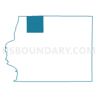
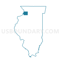
Outline

Summary
| Unique Area Identifier | 575191 |
| Name | USTICK Voting District |
| County | Whiteside County |
| State | Illinois |
| Area (square miles) | 35.40 |
| Land Area (square miles) | 35.39 |
| Water Area (square miles) | 0.01 |
| % of Land Area | 99.96 |
| % of Water Area | 0.04 |
| Latitude of the Internal Point | 41.88126200 |
| Longtitude of the Internal Point | -90.02679910 |
Maps

Graphs
Select a template below for downloading or customizing gragh for USTICK Voting District, Whiteside County, Illinois


Neighbors
Neighoring Voting District (by Name) Neighboring Voting District on the Map
- CLYDE Voting District, Whiteside County, IL
- FAIR HAVEN Voting District, Carroll County, IL
- FULTON 3 Voting District, Whiteside County, IL
- FULTON 4 Voting District, Whiteside County, IL
- GARDEN PLAIN Voting District, Whiteside County, IL
- MT PLEASANT 2 Voting District, Whiteside County, IL
- UNION GROVE Voting District, Whiteside County, IL
- YORK Voting District, Carroll County, IL
Top 10 Neighboring County Subdivision (by Population) Neighboring County Subdivision on the Map
- Mount Pleasant township, Whiteside County, IL (4,939)
- Fulton township, Whiteside County, IL (4,251)
- York township, Carroll County, IL (1,734)
- Union Grove township, Whiteside County, IL (1,244)
- Garden Plain township, Whiteside County, IL (1,072)
- Fairhaven township, Carroll County, IL (910)
- Ustick township, Whiteside County, IL (613)
- Clyde township, Whiteside County, IL (402)
Top 10 Neighboring Unified School District (by Population) Neighboring Unified School District on the Map
- West Carroll Community Unit School District 314, IL (8,701)
- Morrison Community Unit School District 6, IL (6,805)
- River Bend Community Unit District 2, IL (6,638)
- Chadwick-Milledgeville Community Unit School District 399, IL (3,021)
Top 10 Neighboring State Legislative District Lower Chamber (by Population) Neighboring State Legislative District Lower Chamber on the Map
Top 10 Neighboring State Legislative District Upper Chamber (by Population) Neighboring State Legislative District Upper Chamber on the Map
Top 10 Neighboring 111th Congressional District (by Population) Neighboring 111th Congressional District on the Map
Top 10 Neighboring Census Tract (by Population) Neighboring Census Tract on the Map
- Census Tract 4, Whiteside County, IL (3,293)
- Census Tract 2, Whiteside County, IL (2,994)
- Census Tract 9606, Carroll County, IL (1,598)